
The MapSwipe App is widely used by many volunteers who donate their time and brain capacity to find buildings or roads on satellite imagery. Just recently we counted the 10,000,000th contribution! After only 6 months since MapSwipe was launched!
The outcome of these efforts are mainly used by humanitarian organisations like MSF, Netherlands Red Cross or CartONG to create HOT Tasking Manager tasks. Recently we have been busy to reveal the power of the data produced. For doing so we focus on several projects:
1. MapSwipe Analytics website: http://mapswipe.geog.uni-heidelberg.de
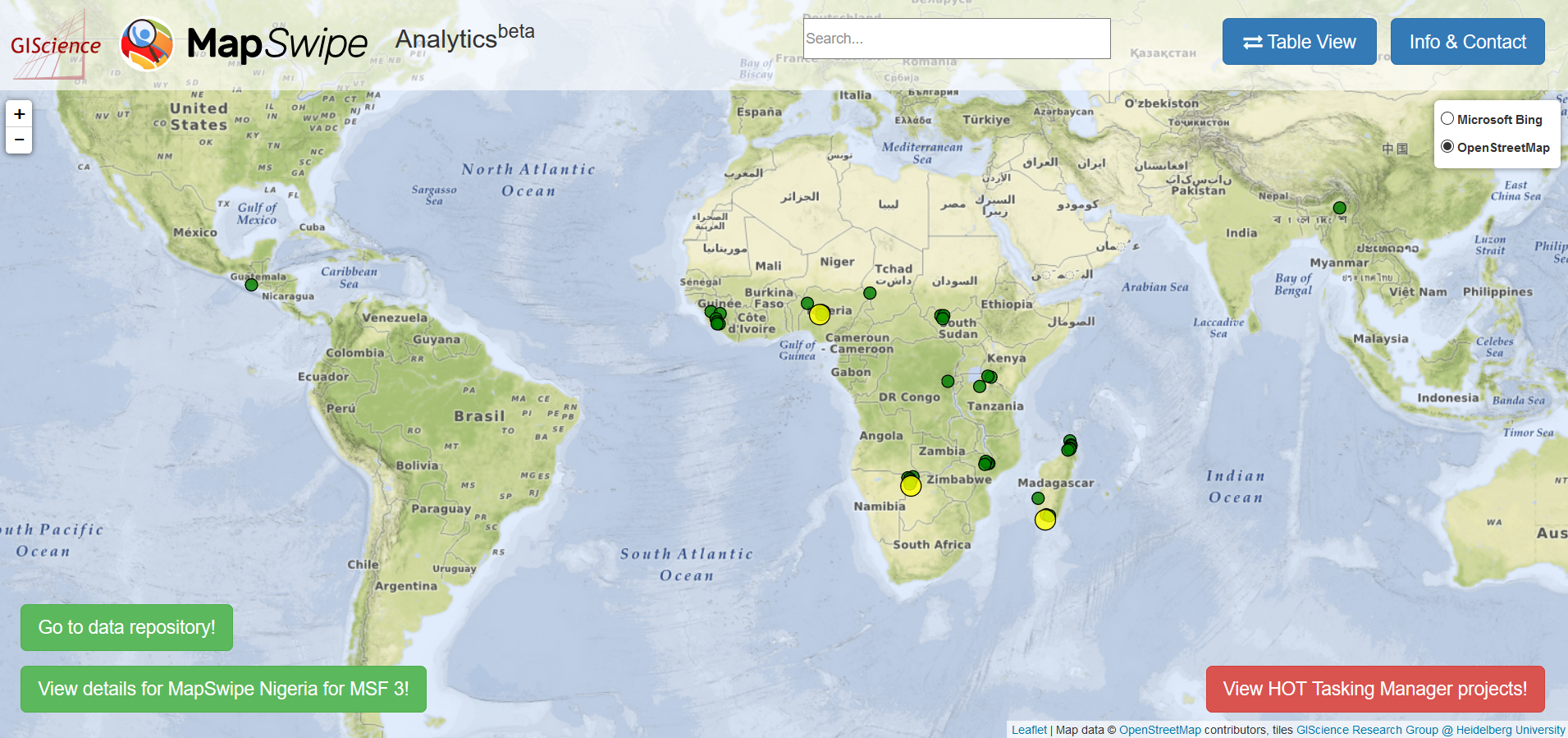
MapSwipe Analytics is a website that brings together everything related to MapSwipe projects. This includes a visualisation of the results (e.g. settlement layer), but also additional characteristics like agreement among volunteers, which is an important indicator for quality. Furthermore, you can monitor the progress of individual MapSwipe projects.
The map view for all projects:
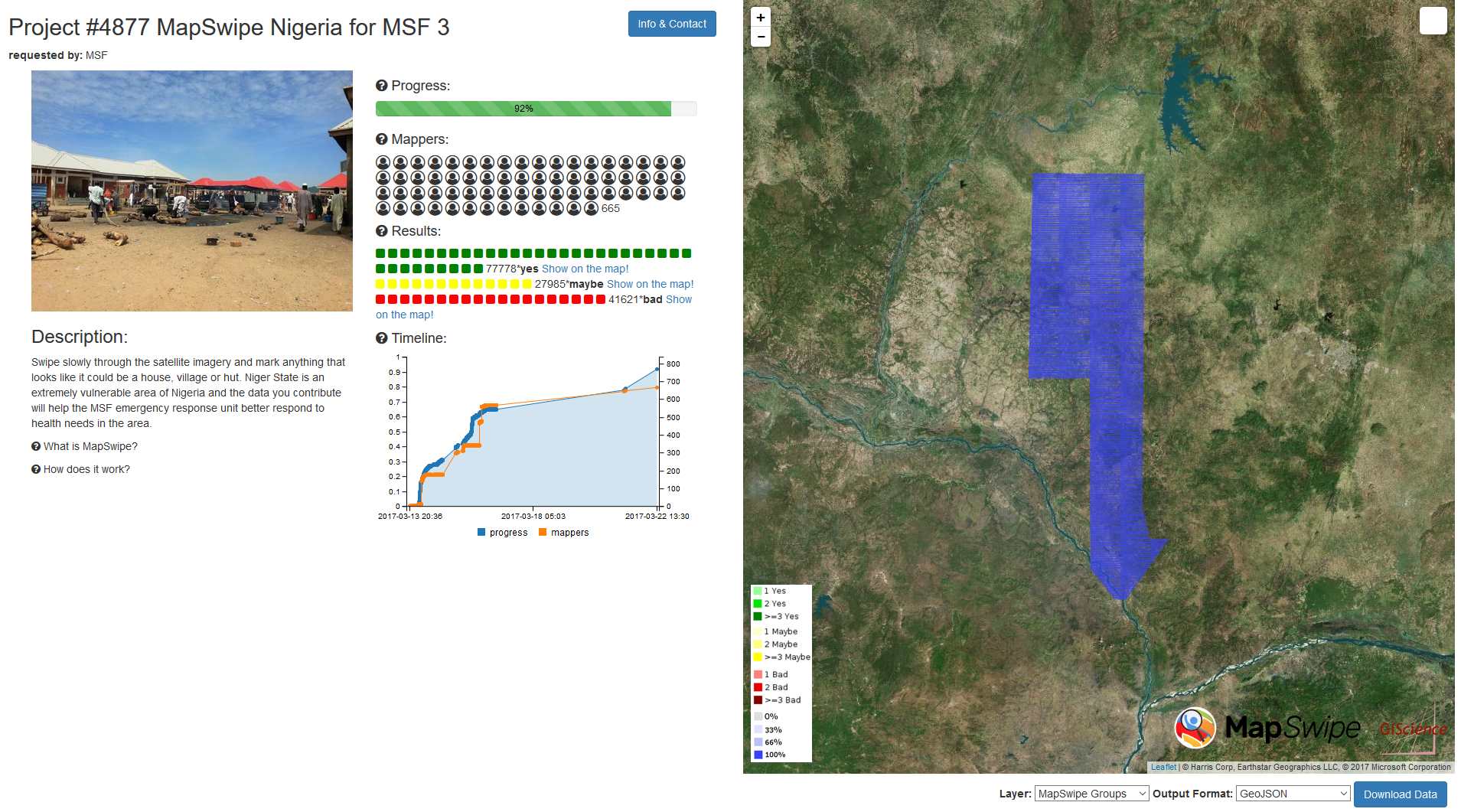
The detailed “analytics” view:
Please note that we are still in the beta mode. We are working on improving the design as well as the analytical features. Your feedback is always welcome. Just post an issue to our GitLab repository: https://gitlab.gistools.geog.uni-heidelberg.de/giscience/mapswipe/MapSwipeAnalytics
2. MapSwipeTools: https://gitlab.gistools.geog.uni-heidelberg.de/giscience/mapswipe/MapSwipeTools
Since, at least three different people work on every MapSwipe tile (that are the little squares) further aggregation of the answers of one tile is needed. But also adjacent tiles marked with the same answer need to be put together. We need to filter out unreliable answers and finally derive geometries that are ready to use in the HOT Tasking Manager. Since, one main goal of MapSwipe is to support the OSM Mapping using the HOT Tasking Manager, we improved our algorithms to minimize the number of tasks and overall area, but still maintain high accuracy.
We provide you with the tools (written in python) to process the data on your own. This gives you the possibility to download and process MapSwipe data at any time and as often as you like. As we are trying to improve the scripts step by step, have a look at the GitLab repo and always get the latest version.
Left: The “old” algorithm derives larger polygons, which tend to be too small or too thin. Right: Using the “new” algorithm the polygons produces polygons that suit better for the OSM mapping.

3. MapSwipe Data Repository: http://mapswipe.geog.uni-heidelberg.de/download/
Sometimes it is not handy or possible to process data on your own. That’s the reason we created the MapSwipe Data repository, where you can just download the processed data from our server. We will update the data every 12 hours. If you cannot wait that long, have a look at the previous section.
The data comes in various categories. The most important ones are shown on the map:
aggregation –> settlement layer
bad_image –> cloud Layer
final –> Tasking Manager task geometries

4. Research Activities:
Besides the development of tools and websites we are also digging deeper into the relationship between data quality and intrinsic characteristics of the MapSwipe data.
Our short paper “Towards evaluating the mobile crowdsourcing of geographic information about human settlements” was accepted for the AGILE conference 2017. Our study identifies several factors that may cause disagreement between volunteers (e.g. bad imagery, dependence on individual users) and thus reduce the reliability of the information they produce. However, such disagreement cases appear not to be random. Their spatially clustered distribution suggests that they are systematically caused by underlying factors.
The insights of this initial study may be used to indicate which types of classification tasks are not well understood by volunteers and tell us where to improve the MapSwipe App.
Herfort, B., Reinmuth, M., Porto de Albuquerque M.J. and Zipf, A. (2017): Towards evaluating the mobile crowdsourcing of geographic information about human settlements. AGILE 2017 International Conference on Geographic Information Science. Wageningen. NL. (accepted).
As this is very much work in progress, stay tuned for more!
🙂
PS: You don’t have the MapSwipe App? Get it here: https://mapswipe.org/
This work has kindly been supported by the Klaus Tschira Foundation, Heidelberg though the core-funding for HeiGIT (Heidelberg Institute for Geoinformation Technology).