• Home
  • About

GIScience News Blog

News of Heidelberg University’s GIScience Research Group.

Feed on
Posts
Comments
« Put the world’s most vulnerable people on the map with MapSwipe
New OpenRouteService QGIS Plugin »

Plausible Parrots - HeiGIT’s OSHDB Supports Research in Citizen Science Data Quality

Feb 27th, 2019 by d1s

In the GIScience research group at Heidelberg University, a recent PhD research project by Clemens Jacobs has been looking into the data quality of citizen science observations of organisms. This research aims at using geographic context as an information source for estimating the plausibility of an observation, e.g., of a bird, which was reported to a citizen science portal collecting such data from volunteers. To this end, approaches were developed which tap into different kinds of sources of Volunteered Geographic Information (VGI) to capture geographic context. One of these sources is OpenStreetMap (OSM). HeiGIT’s OpenStreetMap History Database (OSHDB) as part of the ohsome OpenStreetMap History Analytics platform was used to derive typical contexts of species in the form of OSM tags which are frequently found close to observations of certain species. This information can then be used to examine the tag context of a new observation of such a species. If the context of an observation fits the typical OSM context well, this indicates a high plausibility of that observation.
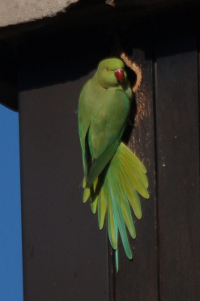
C. jacobs)

Rose-ringed Parakeet on Heidelberg University Campus (Photo: C. jacobs)

Let’s make an example. Rose-ringed Parakeets (Psittacula krameri) are a species of parrots. In Germany, they have been spreading since the late 1960s. They live mostly in urban areas, where they use tree holes, but also holes in buildings, for breeding. They reached the region around Heidelberg and Mannheim in the early 1970s. The map below shows plausibility estimations based on OSM tag context for 111 observations of Rose-ringed Parakeets in or around Heidelberg and Mannheim. These observations were reported to iNaturalist, an American project which collects observations of organisms from volunteers all over the world. The Rose-ringed Parakeet’s typical OSM context, on which this estimation is based, was extracted with the help of observations from ArtenFinder, a citizen science project with similar aim and properties as iNaturalist which is active in the federal state of Rheinland-Pfalz (covering parts of the area shown in the map below, west of the river Rhine). Plausibility estimation in the light of OSM context shows relatively high or medium values for observations in or close to urban centers, while some observations in more rural settings in the western part of the focus area of this example (see map below) present cases of lower plausibility. In this example, plausibility was estimated by comparing the observations’ OSM context and the Rose-ringed Parakeet’s typical OSM context with the help of the Jaccard index, a well-known coefficient for measuring the similarity of the biodiversity at different sites. Observation locations which are away from urban centers appear less plausible, because OSM context differs from the typical situations in which Rose-ringed Parakeets are usually observed. Therefore, this approach can be used to automatically identify unusual observations which might need closer examination in quality assurance of such observation data. It also proves high plausibility of observations in typical situations, which need not be further scrutinized.
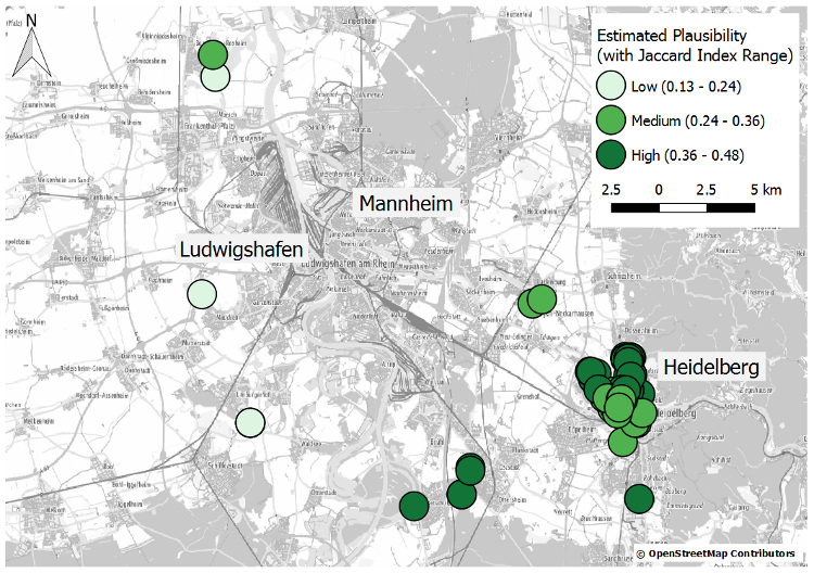
lausibility estimation of observations of Rose-ringed Parakeet based on OSM context (observations from iNaturalist)

Plausibility estimation of observations of Rose-ringed Parakeet based on OSM context (observations from iNaturalist, www.inaturalist.org)

C. Jacobs)

Rose-ringed Parakeet on Heidelberg University Campus (Photo: C. Jacobs)

This research, presented here in much simplified form, contributes to the development of approaches which allow for automatic quality assessment of citizen science observations of organisms. Such approaches can support quality assurance by identifying unusual observations, and by proving high quality of others. This may reduce the workload for experts in charge of quality control, and may render data quality more transparent for any user of such data. HeiGIT’s OSHDB and the tools surrounding it, especially the OHSOME API, provide the necessary infrastructure for the implementation of this approach in a proper methodology.

Some related results can also be found here:

Jacobs C. and A. Zipf (2017): Completeness of Citizen Science Biodiversity Data from a Volunteered Geographic Information Perspective. Geo-Spatial information Science, GSIS, 2017. Taylor & Francis. DOI: 10.1080/10095020.2017.1288424.

Tags: Citizen Science, data quality, ohsome, ohsome example, OpenStreetMap, oshdb, Volunteered Geographic Information

Posted in OSM, Research

Comments are closed.

  • About

    GIScience News Blog
    News of Heidelberg University’s GIScience Research Group.
    There are 1,679 Posts and 0 Comments so far.

  • Meta

    • Log in
    • Entries RSS
    • Comments RSS
    • WordPress.org
  • Recent Posts

    • High Resolution Data Insights from OpenStreetMap Element Vectorisation
    • Data publication: Point clouds of snow-on and snow-off forest site
    • Job Offer: Deep Learning Engineer (m/f/d, up to 100%)
    • GIScience Postdoc/Senior Researcher Opportunity for OpenStreetMap Road Quality Analysis
    • Assessing road criticality and loss of healthcare accessibility during floods: the case of Cyclone Idai, Mozambique 2019
  • Tags

    3D 3DGEO Big Spatial Data CAP4Access Citizen Science Conference crisis mapping Crowdsourcing data quality deep learning disaster DisasterMapping GeoNet.MRN GIScience heigit HOT humanitarian humanitarian mapping Humanitarian OpenStreetMap team intrinsic quality analysis landuse laser scanning Lidar machine-learning Mapathon MapSwipe MissingMaps Missing Maps ohsome ohsome example Open data openrouteservice OpenStreetMap OSM OSM History Analytics Public Health Quality quality analysis remote sensing routing social media spatial analysis Teaching VGI Workshop
  • Archives

    • February 2023
    • January 2023
    • December 2022
    • November 2022
    • October 2022
    • September 2022
    • August 2022
    • July 2022
    • June 2022
    • May 2022
    • April 2022
    • March 2022
    • February 2022
    • January 2022
    • December 2021
    • November 2021
    • October 2021
    • September 2021
    • August 2021
    • July 2021
    • June 2021
    • May 2021
    • April 2021
    • March 2021
    • February 2021
    • January 2021
    • December 2020
    • November 2020
    • October 2020
    • September 2020
    • August 2020
    • July 2020
    • June 2020
    • May 2020
    • April 2020
    • March 2020
    • February 2020
    • January 2020
    • December 2019
    • November 2019
    • October 2019
    • September 2019
    • August 2019
    • July 2019
    • June 2019
    • May 2019
    • April 2019
    • March 2019
    • February 2019
    • January 2019
    • December 2018
    • November 2018
    • October 2018
    • September 2018
    • August 2018
    • July 2018
    • June 2018
    • May 2018
    • April 2018
    • March 2018
    • February 2018
    • January 2018
    • December 2017
    • November 2017
    • October 2017
    • September 2017
    • August 2017
    • July 2017
    • June 2017
    • May 2017
    • April 2017
    • March 2017
    • February 2017
    • January 2017
    • December 2016
    • November 2016
    • October 2016
    • September 2016
    • August 2016
    • July 2016
    • June 2016
    • May 2016
    • April 2016
    • March 2016
    • February 2016
    • January 2016
    • December 2015
    • November 2015
    • October 2015
    • September 2015
    • August 2015
    • July 2015
    • June 2015
    • May 2015
    • April 2015
    • March 2015
    • February 2015
    • January 2015
    • December 2014
    • November 2014
    • October 2014
    • September 2014
    • August 2014
    • July 2014
    • June 2014
    • May 2014
    • April 2014
    • March 2014
    • February 2014
    • January 2014
    • December 2013
    • November 2013
    • October 2013
    • September 2013
    • August 2013
    • July 2013
    • June 2013
    • May 2013
    • April 2013
  •  

    February 2019
    M T W T F S S
    « Jan   Mar »
     123
    45678910
    11121314151617
    18192021222324
    25262728  
  • Recent Comments

    GIScience News Blog CC by-nc-sa Some Rights Reserved.

    Free WordPress Themes | Fresh WordPress Themes