
Am am 29.10.20, 16:30 Uhr veranstaltet das Netzwerk Geoinformation der Metropolregion Rhein-Neckar GeoNet.MRN zum Thema:
Flächennutzung und Flächenmanagement: Ein Geoinformation Meetup
Teilnahme: Kostenlos und ohne Anmeldung mit Teams unter diesem Link.
Themen des Meetups sind die Online-Beteiligung von Kommunen, Bürgern sowie Firmen und Institutionen im Bereich Flächenmanagement mit Fokus auf die Siedlungs- und Verkehrsentwicklung und die Vorstellung von OSM Landuse der Abteilung Geoinformatik der Universität Heidelberg.
Der erste Teil des Meetups, der von Sandra Lanig, Mitarbeiterin des GeoNet.MRN-Mitglieds mena GmbH, (und frühere Mitarbeiterin bei Prof. A. Zipf, GIScience HD siehe Lit.) gestaltet wird, beschäftigt sich mit der Online-Beteiligung von Kommunen, Bürgern sowie Firmen und Institutionen im Bereich Flächenmanagement mit Fokus auf die Siedlungs- und Verkehrsentwicklung am Beispiel des Projektes „Regionale Mobilitäts- und Siedlungsgutachten 2035 (REMOSI) für die Region Bayerischer Untermain“.
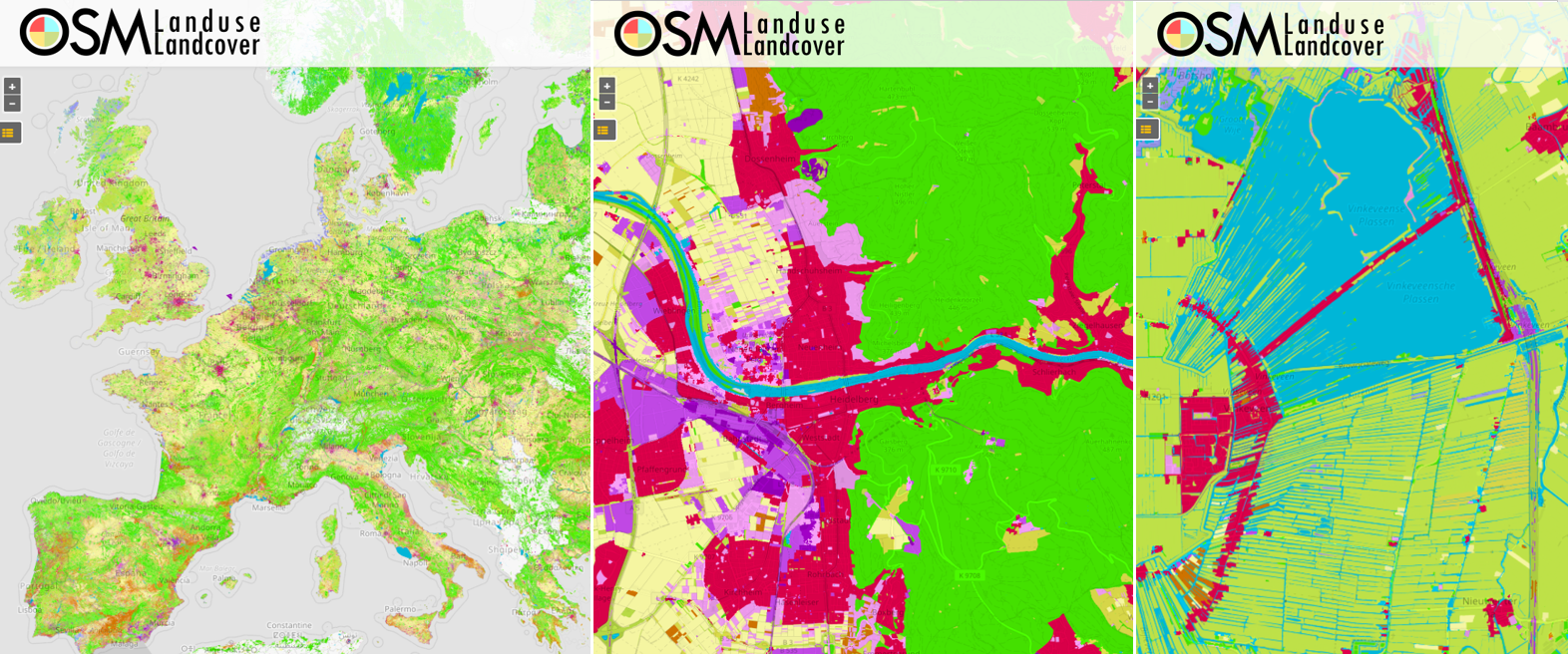
Im zweiten Teil (ab ca. 17.15 Uhr) stellt Michael Schulz (Uni Heidelberg, Abteilung Geoinformatik/GIScience) OSM Landuse vor. OSM Landuse ist die erste großflächige Fusion von OSM und Copernicus Daten mit einer räumlichen Auflösung von 10 m oder höher. Mittels Deep Learning wurden Lücken zu Landnutzungsinformationen in OpenStreetMap durch Ableitung entsprechender Informationen aus Sentinel Daten gefüllt. Der Datensatz liegt nun neu für sämtliche Mitgliedstaaten der Europäischen Union vor.
Die Bereitstellung online erfolgt durch Unterstützung der HeiGIT gGmbH. Die Qualität des Datensatzes wird durch Freiwillige in einer Online-Kampange validiert. Hierbei können Sie online teilnehmen. Weitere Details zur Validierungs-Kampagne finden sie hier.
Wir freuen uns auf Ihre Teilnahme!
Literatur und Vorarbeiten:
- Schultz, M., Voss, J., Auer, M., Carter, S., and Zipf, A. (2017): Open land cover from OpenStreetMap and remote sensing. International Journal of Applied Earth Observation and Geoinformation, 63, pp. 206-213. DOI: 10.1016/j.jag.2017.07.014.
- Wu, Zhaoyan, Li, Hao, & Zipf, Alexander. (2020). From Historical OpenStreetMap data to customized training samples for geospatial machine learning. In proceedings of the Academic Track at the State of the Map 2020 Online Conference, July 4-5 2020. DOI: http://doi.org/10.5281/zenodo.3923040
- Yan, Y., Schultz, M., Zipf, A. (2019): An exploratory analysis of usability of Flickr tags for land use/land cover attribution, Geo-spatial Information Science (GSIS), Taylor & Francis. https://doi.org/10.1080/10095020.2018.1560044
- Jokar Arsanjani, J., Mooney, P., Zipf, A., Schauss, A., (2015): Quality assessment of the contributed land use information from OpenStreetMap versus authoritative datasets. In: Jokar Arsanjani, J., Zipf, A., Mooney, P., Helbich, M., (eds) OpenStreetMap in GIScience: experiences, research, applications. ISBN:978-3-319-14279-1, pp. 37-51, Springer Press.
- Jokar Arsanjani, J., Helbich, M., Bakillah, M., Hagenauer,J. & Zipf, A. (2013): Toward mapping land-use patterns from volunteered geographic information. International Journal of Geographical Information Science (IJGIS). Taylor & Francis. DOI: 10.1080/13658816.2013.800871.
- Dorn, H., Törnros, T. & Zipf, A. (2015): Quality Evaluation of VGI using Authoritative Data – A Comparison with Land Use Data in Southern Germany. ISPRS International Journal of Geo-Information. Vol 4(3), pp. 1657-1671, doi: 10.3390/ijgi4031657
- Li, H., Herfort, B., Huang, W., Zia, M. and Zipf, A. (2020):
Exploration of OpenStreetMap Missing Built-up Areas using Twitter Hierarchical Clustering and Deep Learning in Mozambique. ISPRS Journal of Photogrammetry and Remote Sensing. https://doi.org/10.1016/j.isprsjprs.2020.05.007 - Li, H.; Ghamisi, P.; Rasti, B.; Wu, Z.; Shapiro, A.; Schultz, M.; Zipf, A. A Multi-Sensor Fusion Framework Based on Coupled Residual Convolutional Neural Networks. Remote Sensing. 2020, 12, 2067. DOI: https://doi.org/10.3390/rs12122067
Sandra Lanig:
- Kurzbach, S., Lanig, S., Pasche, E. & Zipf, A. (2009): Benefits of Grid Computing for Flood Modeling in Service-Oriented Spatial Data Infrastructures. GIS.Science. Die Zeitschrift für Geoinformatik. Vol.3, pp. 89-97.
- Lanig, S. & Zipf, A. (2009): Interoperable processing of digital elevation models in grid infrastructures. Earth Science Informatics. Vol.2, pp.107–116. DOI 10.1007/s12145-009-0030-y.
- Schilling, A., Lanig, S., Neis, P. & Zipf, A. (2008): Integrating Terrain Surface and Street Network for 3D Routing. 3D Geoinfo 08. 3rd International Workshop on 3D Geo-Information. Seoul. South Korea.
- Auer, M., Höfle, B., Lanig, S., Schilling, A. & Zipf, A. (2011): 3D-Sutras: A web based atlas of laser scanned Buddhist stone inscriptions in China. 14th AGILE International Conference on Geographic Information Science. 18-21 April 2011 – Utrecht, The Netherlands.
- Lanig, S. & Zipf, A. (2010): Proposal for a Web Processing Services (WPS) Application Profile for 3D Processing Analysis. GEOProcessing 2010 – The Second International Conference on Advanced Geographic Information Systems, Applications, and Services. Netherlands Antilles.
- Lanig, S. & Zipf, A. (2009): Towards generalization processes of LiDAR data based on GRID and OGC Web Processing Services (WPS). Geoinformatik 2009. Osnabrück.
- Over, M., Schilling, A., Neubauer, S., Lanig, S. & Zipf, A. (2009): Virtuelle 3D Stadt- und Landschaftsmodelle auf Basis freier Geodaten. AGIT 2009. Symposium für Angewandte Geoinformatik. Salzburg. Austria.
- Lanig, S. & Zipf, A. (2010): Standardkonforme Geodatenverarbeitung und Diensteorchestrierung am Beispiel der Solarpotenzialanalyse mittels OGC Web Processing Service (WPS). AGIT 2010. Symposium für Angewandte Geoinformatik. Salzburg. Austria.
- Lanig, S., Klärle, M. & Zipf, A. (2009): Offenes, nachhaltiges Landmanagement mittels standardisierter Web Processing Services (WPS). AGIT 2009. Symposium für Angewandte Geoinformatik. Salzburg. Austria.