• Home
  • About

GIScience News Blog

News of Heidelberg University’s GIScience Research Group.

Feed on
Posts
Comments
« Open Data + Open Software - A perfect match
Successful PhD Defense by Amin Mobasheri on OSM quality enrichment for wheelchair routing »

New paper published about the OSM Sketch Map Tool

Mar 4th, 2021 by Carolin Klonner

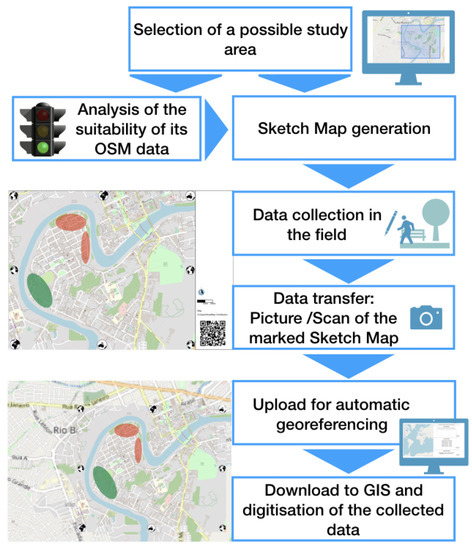
The Sketch Map Tool supports participatory mapping approaches and risk communication. An new paper presents the different functionalities of the tool. OSM data quality can be evaluated regarding the fitness for the sketch-map-approach. Based on the great idea of Field Papers, paper maps can be printed out for the use in the field, and afterwards, the marked sketch maps can be uploaded. They are georeferenced automatically. In addition to the Field Papers homepage, the Sketch Map Tool makes it possible to print the maps in more formats. Thus, if you would like to do a group mapping event, you can print the maps in DIN A0.

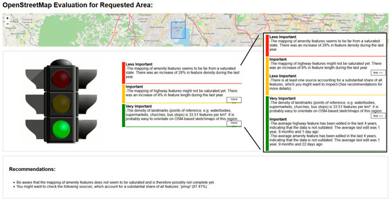
Since the tool will be open-source and several analyses are made automatically, the tool also offers a method for local governments in areas where historic data or financial means for flood mitigation are limited. Example analyses for two cities in Brazil show the functionalities of the tool and allow the evaluation of its applicability. Results depict that the fitness-for-purpose analysis of the OpenStreetMap data reveals promising results to identify whether the sketch map approach can be used in a certain area or if citizens might have problems with marking their flood experiences. In this way, an intrinsic quality analysis is incorporated into a participatory mapping approach. Additionally, different paper formats offered for printing enable not only individual mapping but also group mapping. Future work will focus on advancing the automation of all steps of the tool to allow members of local governments without specific technical knowledge to apply the Sketch Map Tool for their own study areas

Klonner, C., Hartmann, M., Dischl, R., Djami, L., Anderson, L., Raifer, M., Lima-Silva, F., Castro Degrossi, L., Zipf, A., Porto de Albuquerque, J. (2021): The Sketch Map Tool Facilitates the Assessment of OpenStreetMap Data for Participatory Mapping. ISPRS Int. J. Geo-Inf., 10, 130. https://doi.org/10.3390/ijgi10030130.


Related work:

Klonner, C., Hartmann, M., Djami, L., Zipf, A. (2019). “Ohsome” OpenStreetMap Data Evaluation: Fitness of Field Papers for Participatory Mapping In: Minghini, M., Grinberger, A.Y., Juhász, L., Yeboah, G., Mooney, P. (Eds.). Proceedings of the Academic Track at the State of the Map 2019, 35-36. Heidelberg.

Klonner, C., Usón, T.J., Aeschbach, N., Höfle, B. (2021): Participatory Mapping and Visualization of Local Knowledge: An Example from Eberbach, Germany. Int J Disaster Risk Sci 12, 56–71. https://doi.org/10.1007/s13753-020-00312-8.

Klonner, C., Hartmann, M., Djami, L., Zipf, A. (2019). “Ohsome” OpenStreetMap Data Evaluation: Fitness of Field Papers for Participatory Mapping. In: Proceedings of the Academic Track at the State of the Map 2019. Heidelberg, Germany, pp. 35-36.

Lightning talk: OpenStreetMap Sketch Map Tool - The Future of OpenStreetMap Field Papers

https://www.geog.uni-heidelberg.de/gis/waterproofing.html

Funded by Belmont Forum and NORFACE joint programme Transformations to Sustainability (T2S) and co-funded by DLR/BMBF (Federal Ministry of Education and Research) as part of its Social-Ecological Research funding priority.

Tags: flood, local knowledge, OSM, Participatory mapping, Sketch Map Tool, Waterproofing data

Posted in Publications, Transdisciplinarity, VGI Group

Comments are closed.

  • About

    GIScience News Blog
    News of Heidelberg University’s GIScience Research Group.
    There are 1,679 Posts and 0 Comments so far.

  • Meta

    • Log in
    • Entries RSS
    • Comments RSS
    • WordPress.org
  • Recent Posts

    • High Resolution Data Insights from OpenStreetMap Element Vectorisation
    • Data publication: Point clouds of snow-on and snow-off forest site
    • Job Offer: Deep Learning Engineer (m/f/d, up to 100%)
    • GIScience Postdoc/Senior Researcher Opportunity for OpenStreetMap Road Quality Analysis
    • Assessing road criticality and loss of healthcare accessibility during floods: the case of Cyclone Idai, Mozambique 2019
  • Tags

    3D 3DGEO Big Spatial Data CAP4Access Citizen Science Conference crisis mapping Crowdsourcing data quality deep learning disaster DisasterMapping GeoNet.MRN GIScience heigit HOT humanitarian humanitarian mapping Humanitarian OpenStreetMap team intrinsic quality analysis landuse laser scanning Lidar machine-learning Mapathon MapSwipe MissingMaps Missing Maps ohsome ohsome example Open data openrouteservice OpenStreetMap OSM OSM History Analytics Public Health Quality quality analysis remote sensing routing social media spatial analysis Teaching VGI Workshop
  • Archives

    • February 2023
    • January 2023
    • December 2022
    • November 2022
    • October 2022
    • September 2022
    • August 2022
    • July 2022
    • June 2022
    • May 2022
    • April 2022
    • March 2022
    • February 2022
    • January 2022
    • December 2021
    • November 2021
    • October 2021
    • September 2021
    • August 2021
    • July 2021
    • June 2021
    • May 2021
    • April 2021
    • March 2021
    • February 2021
    • January 2021
    • December 2020
    • November 2020
    • October 2020
    • September 2020
    • August 2020
    • July 2020
    • June 2020
    • May 2020
    • April 2020
    • March 2020
    • February 2020
    • January 2020
    • December 2019
    • November 2019
    • October 2019
    • September 2019
    • August 2019
    • July 2019
    • June 2019
    • May 2019
    • April 2019
    • March 2019
    • February 2019
    • January 2019
    • December 2018
    • November 2018
    • October 2018
    • September 2018
    • August 2018
    • July 2018
    • June 2018
    • May 2018
    • April 2018
    • March 2018
    • February 2018
    • January 2018
    • December 2017
    • November 2017
    • October 2017
    • September 2017
    • August 2017
    • July 2017
    • June 2017
    • May 2017
    • April 2017
    • March 2017
    • February 2017
    • January 2017
    • December 2016
    • November 2016
    • October 2016
    • September 2016
    • August 2016
    • July 2016
    • June 2016
    • May 2016
    • April 2016
    • March 2016
    • February 2016
    • January 2016
    • December 2015
    • November 2015
    • October 2015
    • September 2015
    • August 2015
    • July 2015
    • June 2015
    • May 2015
    • April 2015
    • March 2015
    • February 2015
    • January 2015
    • December 2014
    • November 2014
    • October 2014
    • September 2014
    • August 2014
    • July 2014
    • June 2014
    • May 2014
    • April 2014
    • March 2014
    • February 2014
    • January 2014
    • December 2013
    • November 2013
    • October 2013
    • September 2013
    • August 2013
    • July 2013
    • June 2013
    • May 2013
    • April 2013
  •  

    March 2021
    M T W T F S S
    « Feb   Apr »
    1234567
    891011121314
    15161718192021
    22232425262728
    293031  
  • Recent Comments

    GIScience News Blog CC by-nc-sa Some Rights Reserved.

    Free WordPress Themes | Fresh WordPress Themes